 This visualization shows sea surface temperatures during most of the 2005 hurricane season. Overlaid are infrared cloud data, storm track data, and storm name labels. Ocean temperatures are the fuel that drive hurricanes. Notice the correspondence between the storm tracks and the sea surface temperature response; this is particulary noticable for hurricanes Dennis, Emily, and Katrina. This versions shows a wide view of the Gulf of Mexico and Western Atlantic Ocean.
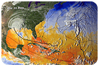
 This visualization includes all of the named storms from Arlene though Wilma; however, Vince is not within the camera's view since it was in the Portugal/Spain region. Wilma ties the record for the most named Atlantic tropical storms in recorded history; and, the list of seleced names for this season is exhausted. If any other storms form after Wilma, they will be named after the Greek alphabet (starting with Alpha).[Read more]

1 comment:
Great blog. please check out my site personal development.
Post a Comment